The Appalachian Mountains |
Location: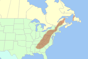 http://en.wikipedia.org/wiki/Appalachian_Mountains http://en.wikipedia.org/wiki/Appalachian_Mountains
This region stretches 2400 km from Newfoundland in the north, west through the Maritime provinces, and south through the US. It includes all of West Virginia and parts of 12 other states: Alabama, Georgia, Kentucky, Maryland, Mississippi, New York, North Carolina, Ohio, Pennsylvania, South Carolina, Tennessee, and Virginia.
Interesting Fact: Forty-two percent of this region’s population lives in rural areas. Interestingly, Canada’s rural population is only twenty percent. It is home to 25 million people. |
The Coastal Plains |
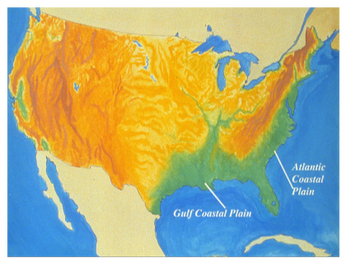 Source: exchange.smarttech.com Source: exchange.smarttech.com
Stretching for 3200 km, the Coastal Plains runs along the Atlantic coast from Cape Cod all the way down to Florida. It then runs westward, continuing along the Gulf of Mexico and into Mexico. A tiny part of southern Alaska is included as well.
|
The Great Lakes - St. Lawrence Lowlands |
 Green Part = The Great Lakes Region Green Part = The Great Lakes Region
This is the smallest geographical region in Canada and includes the triangle, which is formed by Lakes Huron, Ontario, and Erie. It also includes the Ile d’Anticosti, which is a small island in the Gulf of St. Lawrence.
|
The Interior Plains |
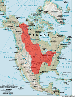 http://en.wikipedia.org/wiki/Interior_Plains http://en.wikipedia.org/wiki/Interior_Plains
Running in between two different mountains, in the US, this region is located between the Appalachian Mountains, which is on the east coast, and the Rocky Mountains in the west. In Canada, the Interior Plains run between the Canadian Shield and the Rocky Mountains. Extending from the Gulf of Mexico to the Arctic Ocean, the region then runs north to south. Due to the large area this region covers, the environment varies greatly.
|
The Canadian Shield |
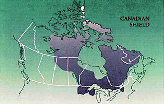 http://ss9geography.wikispaces.com/Canadian+Shield+No.+2 http://ss9geography.wikispaces.com/Canadian+Shield+No.+2
Centered on Hudson Bay, this region extends for 8 million km over eastern, central, and northern Canada. This region includes Labrador and James Bay and also stretches west into the Interior Plains. In the north, the Canadian Shield extends from the Arctic Ocean all the way south to the Great Lakes. This covers over half of Canada and also extends south into the northern reaches of the US.
|
The Western Cordillera |
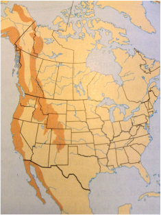 Crossroads a Meeting of Nations - pg. 174 Crossroads a Meeting of Nations - pg. 174
The Western Cordillera runs along the west coast of North America. It consists of ranges of mountain belts some 800 km wide, which are separated by plateaus and valleys. Stretching all the way into the US, the Rocky Mountains are the most easterly range of mountains. This region includes some of British Columbia, some of the Yukon, southwest Alberta, and parts of the North West Territories.
|
The Intermountain Region |
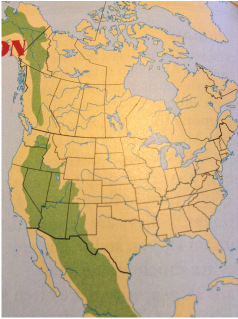 Crossroads a Meeting of Nations - pg. 176 Crossroads a Meeting of Nations - pg. 176
This region covers vast areas in the US and Canada. It is located between the Rocky Mountains, the Coast Mountains, the Cascades and the Sierra Nevada. The Sierra Nevada is a mountain range located in western US, lying mostly in California. The Cascades is situated in the western part of North America, stretching from southern British Columbia, Washington, Oregon, and to Northern California. These mountains both are non-volcanic and highly volcanic.
|
The Arctic |
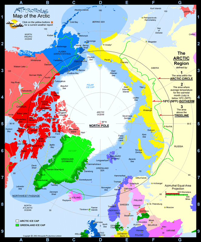
Red part = Canada's Arctic
This region in Canada is located in the very north. It consists of the many islands in the north such as Victoria Island, Queen Elizabeth Islands, and parts of Baffin Island.
Picture Source: http://www.athropolis.com/map3.htm |
